

N.C. A&T Joins NCShare Partnership, Enhances Computing and Data Modeling Capacity
04/23/2025 in Research, College of Engineering
By Jamie Crockett / 03/10/2025 Research, College of Science and Technology
EAST GREENSBORO, N.C. (March 10, 2025) — Researchers at North Carolina Agricultural and Technical State University, Wake Forest University (WFU) and North Carolina Central University (NCCU) are developing a low-cost and comprehensive lake water quality monitoring system for communities looking for clean water solutions.
Funded by a North Carolina Attorney General’s Office Environmental Enhancement Grant (EEG), the collaborative project combines remotely sensed information from satellites and drones with existing data and operational monitoring procedures.
The N.C. A&T team has conducted and analyzed machine learning models for two satellite remote sensing datasets for water quality assessment in High Rock Lake, which is situated on the Yadkin River.
“We want to assess advanced remote sensing approaches to monitor water quality changes over time,” said Leila Hashemi Beni, Ph.D., an associate professor in the Department of Built Environment at A&T’s College of Science and Technology. “By leveraging freely available satellite imagery, collecting drone data and harnessing geospatial data science, we can get a broader view of water conditions over time, something that would be difficult with just in-situ sampling. We use water samples collected and analyzed by our partners at WFU for algorithms development and validation.”
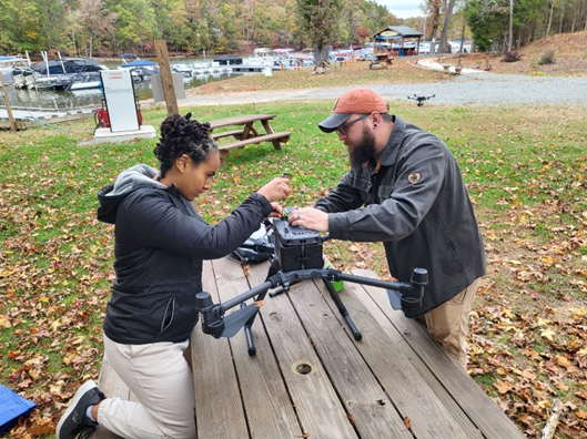
As part of the project, Eden Wasehun, Hashemi Beni’s Ph.D. advisee in the Applied Science and Technology (AST) program, worked with the WFU water sampling collection team led by Courtney Di Vittorio, Ph.D., PE with handheld radiometers to capture water reflectance readings. She also collaborated with Christopher Zarzar, Ph.D., from industry partner Truweather Solutions, and Michael Lee Berryann, an MSc student from NCCU, to collect drone data over the water. Berryann has since graduated from NCCU and joined Hashemi Beni’s Geospatial and Remote Sensing lab to pursue a Ph.D. in the AST program.
“We analyze the data using machine learning and artificial intelligence to develop a method to estimate the water’s chlorophyll levels, because when concentration increases to a certain level, the algal bloom issue increases,” said Wasehun.
Algae blooms can be harmful to animals and people because of the rapid growth of algae in a body of fresh water as a result of nutrient pollution.
“High Rock Lake is a man-made reservoir that has had a consistent issue with the chlorophyll concentration since the 1970,” said Wasehun. “We are studying more inland waters than open ocean waters because inland waters are a bit complex. These types of water bodies we’re studying integrate with the community or inside urban areas.”
Wasehun is the first author of the article, “Comparative analysis of Sentinel-2 and PlanetScope imagery for chlorophyll-a prediction using machine learning models,” published in Ecological Informatics. The authors reviewed earlier literature which discussed the importance of inland water bodies to irrigation, freshwater resources and power generation and some of the challenges:
“However, the proximity of these water bodies to settlements and human activity makes them susceptible to various pollutants originating from anthropogenic activities, such as agricultural runoff, and urbanization, as well as natural sources such as natural forests (N.C. Division of Water Resources, 2021). This results in the accumulation of nutrients in the water, leading to high chlorophyll-a (Chl-a) concentration,” researchers said in the article.
“We used field data collected from 2022 and 2023, which has an overpass with the satellite imagery that helped us extract the field measurement by overlaying it with the satellite imagery,” said Wasehun. “From there we fed the data to our machine learning models to help us predict the chlorophyll concentration.”
“Each machine learning model demonstrated various aspects of observed Chl-a concentrations. For example, XGBoost effectively captured average Chl-a concentrations using Sentinel 2 data, while SVR excelled in estimating low Chl-a concentrations using PlanetScope imagery,” the researchers concluded.
The authors encouraged future research to develop integrated approaches when using both datasets.
Hashemi Beni recently discussed this work in Denver at the 2025 GEO Week, an international conference that brings together geospatial experts to discuss technology and other advancements used to solve various problems in communities.
The ultimate goal of the partnership between A&T, WFU and NCCU is to create “comprehensive and low-cost lake water quality monitoring systems for North Carolina lakes."
Media Contact Information: jicrockett@ncat.edu
